Airport Expansion Overview
The Plymouth Municipal Airport is in West Plymouth on South Meadow Road and extends into Carver.
The Airport Commissioners propose to extend the runway, build two new hangers, reconstruct a taxi lane and runway and extend water and sewer lines.
UPDATE: January 16, 2024 State Issues MEPA “Certificate”
The Certificate is here MEPA Certificate Jan. 16, 2024
The Secretary of Energy and Environmental Affairs Rebecca Tepper says the Airport’s “Draft Environmental Impact Report” “adequately and properly” complies with the state’s environmental study law, MEPA. The next step is for the Airport to do a “Final Environmental Impact Report.”
The public’s comments submitted to the state made a difference!
The Airport has to do more study of the drinking water aquifer and how the Airport could impact water.
Attend Airport Commissioner’s Meetings.
Next meeting March 7, 2024 at 7 p.m. at the Airport
The agendas are posted here on the Town of Plymouth Website.
Contact the Airport Manager and Commissioners and ask to be on the Agenda to get your questions answered!
Plymouth Municipal Airport
246 South Meadow Road
Plymouth, MA 02360
Tel : (508) 746-2020
Fax: (508) 747-4483
Email: mcardillo@plymouth-ma.gov
Make comments and questions at public comment at the meetings.
Check out the Airport website
Demand transparency and accountability!
Demand compliance with the Open Meeting Law
Are their “executive sessions” legal?
Issues
Get the Fact Sheet by clicking here
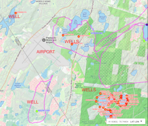
- Drinking water Will Airport expansion harm our drinking water? Section 4.2 of the study says drinking water wells are “not affected”. The study does not give enough information about this conclusion.
- Our water comes from the underground Plymouth Carver Sole Source Aquifer. The groundwater is vulnerable to contamination.
- The Town’s 2019 draft water system master plan says the Airport “is located adjacent to the Zone II area [protection area] for the Federal Furnace Well and could be a potential source for per and polyfluoroalkyl substances (PFAS).”
- PFAS is a type of chemical that causes health problems, including cancer.
- The Town’s 2019 draft water system master plan says we should be doing more to protect our wells: “Considering how susceptible the [Town’s] sources are to contamination; it is recommended that a more stringent groundwater protection district be developed.”
- Private drinking water wells may also be impacted
- Air pollution The study used an air station in Boston to conclude that air pollution is not a problem. The Airport must test current air pollution near the Airport and guarantee that the fumes from the Airport are not harming people now or in the future.
- Noise and Light pollution
Find out more:
Airport Website Environmental Study
Get in touch: environmentwatchsoutheasternma@gmail.com
Below: MAP OF WELLS AROUND THE AIRPORT: Available at MassMapper GIS – a free mapping system from the Commonwealth of Massachusetts