Region’s major sand mining operator, EJ Pontiff proposes 33 acre mine to level one of the last remaining hills at 71 Hedges Pond Road
Plymouth Foundation, a charity, involved in — this is its second land grab for sand and gravel on Hedges Pond Road
Pontiff mining will destroy nationally significant Native American historical site, forests, create traffic with no environmental study
Dec. 16th 2024: Attend the ZBA meeting and tell the ZBA to deny the permit!
7:00 pm Great Hall, 2nd Floor, 26 Court St. Plymouth, MA.
Dec 4th 2024: Planning Board Approves Proposal. Watch the Recording here.
The Town Planning Board voted to allow the current sand mine proposal at 71 Hedges Pond Road bypass a public Zoning Board of Appeals (ZBA) hearing. The Planning Board voted to recommend the project 4-0 to the Building Commissioner. Read the Draft Planning Board Advisory Report from December 5th, 2024 here.
Contact Town Officials & Hold Them Accountable!
Take Action: Send a letter today to the Building Inspector, Jason Silva and the Plymouth Select board telling them to deny the permit. Use this link here.
Contact Jason Silva the building inspector here, or call 508-322-3358 to tell him not to issue the building permit
Contact Town Officials & Hold Them Accountable!
Selectboard: Chair, Richard Quintal and other board members: selectboard@plymouth.ma-gov
Town Manager: Derek Brindisi
Planning Board: Chair, Steve Bolotin
CLWC Sept. 9, 2024 Info Session recorded here.


Plymouth Planning Board: upcoming meeting in October 202”
Town Hall, 26 Court Street at 7 p.m.
Background
1800s: First “Indian Reservation” in the USA
The Plymouth Foundation and EJ Pontiff sand mining operation is proposed for land that is part of one of the most significant Native American archeological areas in the United States. This is the site of the first government established “Indian Reservation” in the United States, known as the Herring Pond Wampanoag Tribe’s “Great Lot”. Read more here.
The Town of Plymouth ended up owning much of the land, likely due to tax takings, taking the land from the Native American people. The map below shows the “Herring Pond Reservation” and the location of the sand mine at the red bubble. The mine is in the area marked “Ancient Indian Plantation.” There has been no archeological study.
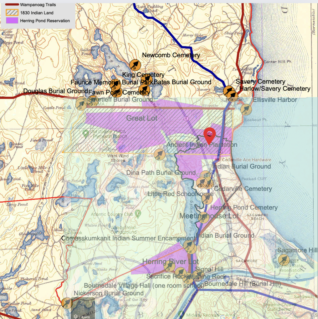
Above: 2024 Current Google Map overlaid with Herring Pond Wampanoag Historical Reservation map. Pink shading indicated the Reservation, and the red pin indicates where the proposed project is. The proposed project at 71 Hedges Pond Road falls within the area known as the Great Lot.
1977: Town acquires 175 acres for future landfill, abandons landfill plan in 1980s
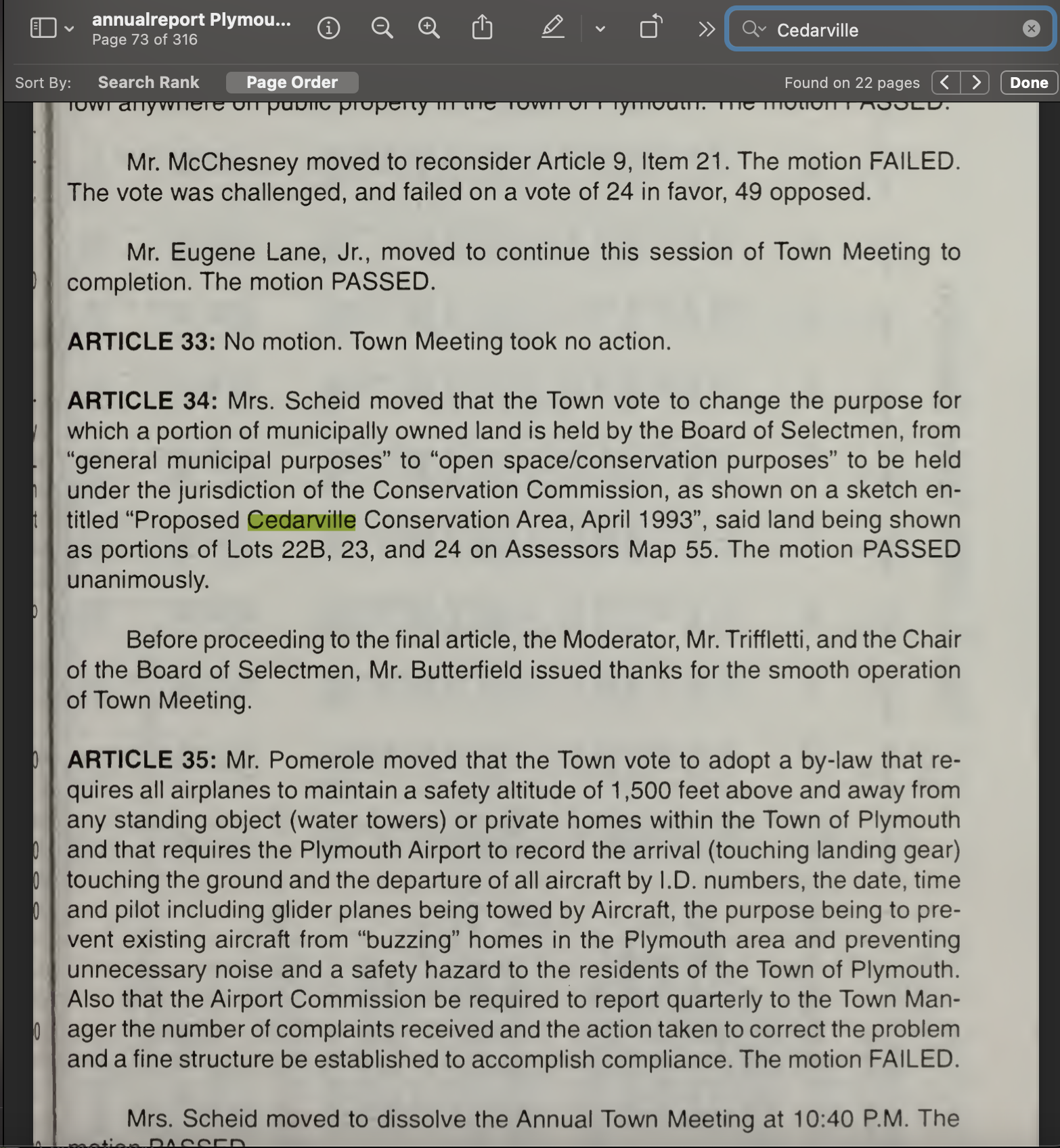
1993 Plymouth Town Meeting votes to put land in custody of Conservation Commission as “Cedarville Conservation Area”
In 1993, a citizen petition placed ARTICLE 34 on the Town Meeting Warrant. It was a vote to create the “Cedarville Conservation Area” on what was then Map 55, Lots 22B, 23, and 23. ARTICLE 34 passed unanimously. See ARTICLE 34 below.
Despite this unanimous vote, the Conservation Commission, Town Selectboard and staff never did what the Town Meeting directed them to do – protect this land. In 2018, the Selectboard, with Chair Cavacco and other Town officials, moved part of the 175 acres, Lot 24-1 land from the control of the Conservation Commission to the Selectboard. Then the Selectboard sold it to the “Plymouth Economic Development Foundation.” Now a sand mining operator, EJ Pontiff, is said to have a purchase and sale agreement for the land.
Below: 1993 Town Report with Article 34 and record of unanimous vote to create the Cedarville Conservation Area. The land was to be moved from municipal use to the jurisdiction of the Conservation Commission.
Above: Article 34 passes unanimously.
2018: Selectboard sells 71 Hedge’s Pond Road (Lot 24-1) mining site to Plymouth Foundation for a $1.00
For 25 years, the Town staff did nothing and left the land in limbo, never taking steps to permanently protect it as was the intent of the Town Meeting unanimous vote in 1993.
In 2018, the Town Director of Planning and Development, Mr. Hartmann, facilitated the transfer of the proposed mining site by shepherding it through Town Meeting and into the hands of to the Plymouth Regional Economic Development Foundation, Inc (PREDF) (now the “Plymouth Foundation”) for $1.00.

The 2018 Town Meeting Warrant Articles 25, 26, and 27 are here.
The Town Meeting vote required the Town to put 134 acres into conservation in exchange for the Selectboard selling the huge hill of sand (Lot 24-1) for $1.00.
The Plymouth Foundation’s Board of Directors includes:
- Rick Vayo, developer
- Dee Wallace Spencer (daughter of developer Tom Wallace)
- Plymouth Town Manager (Derek Brindisi)
- Selectboard Chair (Richard Quintal),
- Director of Planning and Development (Lee Hartmann),
- State representative Matthew Muratore and others.
The land has sand and gravel estimated to generated at least $5 million. After mining, Pontiff can sell the building lots for millions more based on going rates.
See relevant portions of the deed below conveying Lot 24-1 of the Cedarville Conservation Area to the Foundation which is now selling it or sold it to Pontiff for mining and development.
DEED FROM SELECTBOARD TO FOUNDATION: signed by Betty Cavacco, Chair, Richard Quintal and others.


2024: Plymouth Foundation enters into sale agreement with mining company, EJ Pontiff
In July, 2024, hiding behind a shell corporation, “Standish Investment” Pontiff, his lawyer and engineers filed a permit application to mine about $5 million in sand cloaking it as a “unified complex” of 4 commercial buildings. What is the role of the Plymouth Foundation in this mining operation?
Pontiff is using a zoning classification as “unified complex.” There is no known definition of a “unified complex” — it opens the door for developers to destroy land with sand mining.
Pontiff claims that to build on the land it just happens to be necessary to do a years long sand and gravel mining operation to excavate and truck off site 350,000 cubic yards of sand and gravel operation. With one truck able to transport approximately 22 cubic yards of sand, there will be over 30,000 truck trips to transport sand from this site. How will this impact traffic and road safety in Cedarville?
In 2020, Scott Spencer, another developer and sand and gravel operator, used the same ruse of a “unified complex” to get a Planning Board permit for the 10+ acre massive years long strip mine happening now on Route 3 South. Watch the drone video here.
Below is the EJ Pontiff/Standish Investment Group “Site Plan” submitted to the Town. Pontiff and his engineers claim the “commercial park” requires removing 350,000 cubic yards of sand and gravel. This will strip the site bare — just like the “Plymouth Foundation” strip mined the adjacent land at Cantor Court starting in 2008. Read more below. See the complete Site Plans and Town’s file for the 71 Hedge’s Pond “Commercial Park” here in a Google Driver Folder.

Below is the letter to the Town on behalf of Pontiff saying to build the commercial park they have to remove 350,000 cubic yards of sand and gravel.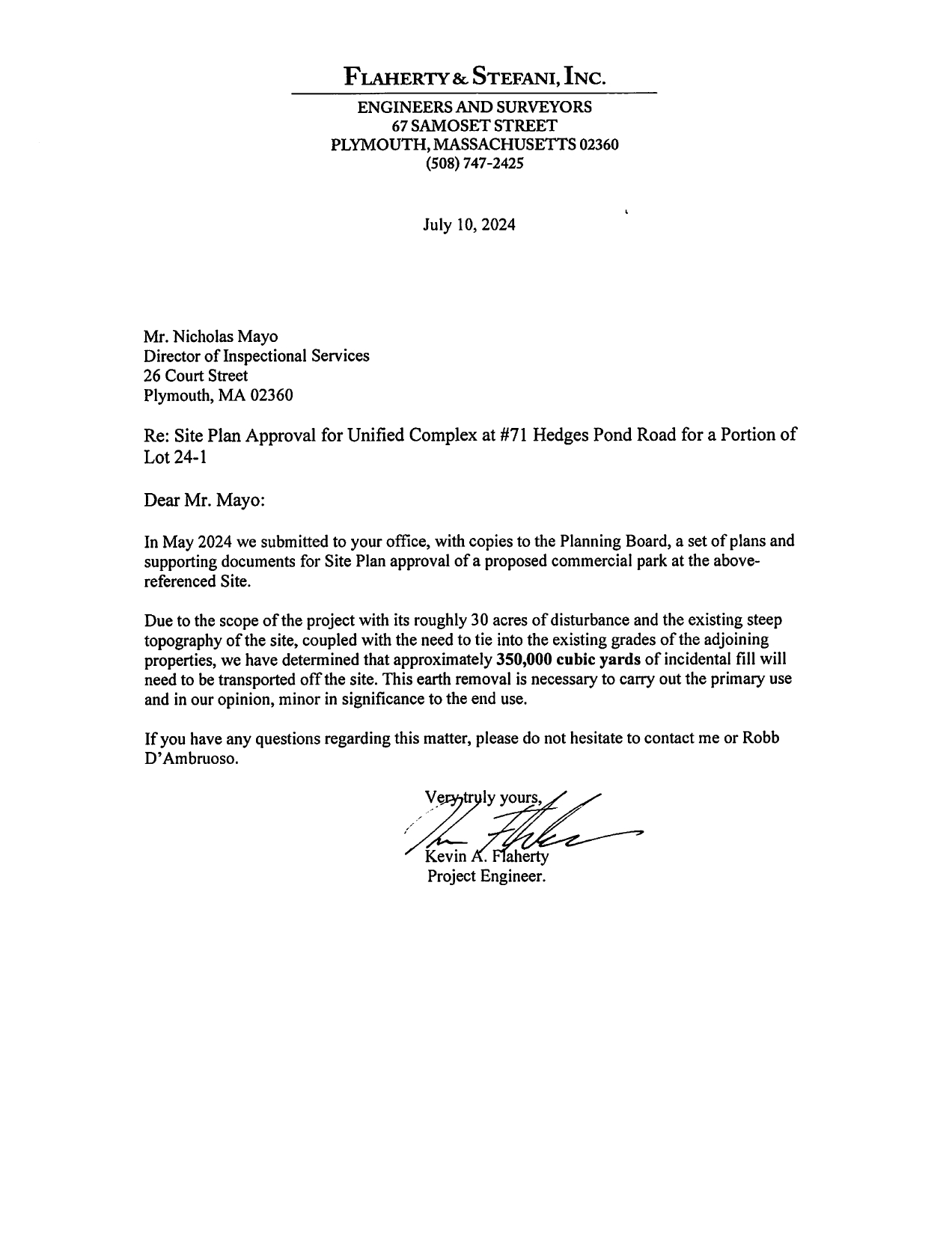
Plymouth “Industrial Park” is also being strip mined for “commercial development”
This is the “commercial development” off Route 3 South in Plymouth. The Planning Board and Zoning Board of Appeals approved this massive years long mine as just “commercial development” in the “Industrial Park.” This was a ruse and pretense for mining. This is the same ruse being used by the Town in Cedarville.
Below: Route 3/10 Collins Ave. in the Plymouth Industrial Park. Sand and gravel mining operation started by Scott Spencer and G. Lopes Construction in 2021. They have excavated so much sand they have dug into the Sole Source Drinking Water Aquifer.

Spencer, apparently connected to Plymouth Foundation’s Dee Wallace Spencer, has been mining the site in violation of numerous laws. Dee Spencer states that she is a small business owner of Scott Spencers, Scobee Spencer Corporation.
As of July 2024, the “earth removal permit” for the Spencer mine above expired. The Planning Board Chair claims to know nothing about the expired permit (conversation with CLWC Meg Sheehan, Spring 2024).
Learn more about Spencer’s 10 Collins ave project off Route 3 in Plymouth here.
Wetlands
In July 2024, Pontiff apparently sidestepped the state Wetlands Protection Act claiming there is no jurisdiction over the project. Plymouth Conservation Commission goes along. This is still under investigation. See Pontiff’s Notice of Intent under the Wetlands Protection Act and Town Bylaw. The Commission voted on July 16, 2024 to grant Pontiff a variance to let the operation destroy a protected wetland area in exchange for a vague promise of “replication” of wetlands under the Bylaw. View the NOI here. CLWC is still waiting for the Commission to provide their official decision pursuant to a Public Records Request. See the July 16th minutes here.
Forests, wildlife
Pontiff tries to rely on 2018 “No Take” approval from state Natural Heritage and Endangered Species Program. See the correspondence below from Pontiff’s lawyer, D’Ambruoso
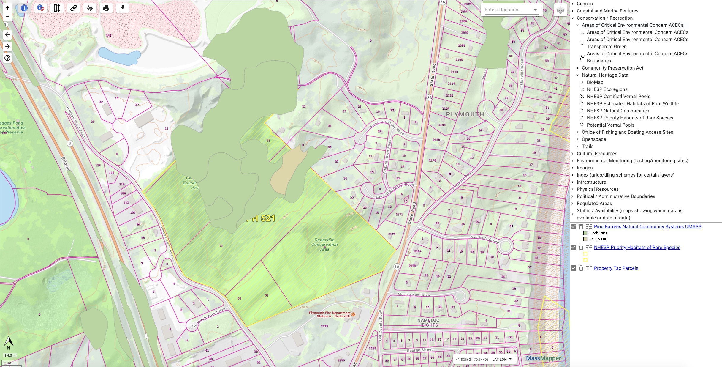
The site is categorized as an NHESP Priority Habitat for rare species and contains globally rare Pine Barrens Forest. Pontiff is evading the state law for an environmental study – MEPA.
Map below showing NHESP Priority Habitat in yellow border, and Pine Barrens forest in green shading.
Pontiff’s history of sand and gravel mining in Plymouth and Carver
Is EJ Pontiff is acting as a front for the sand mining industry in applying for the Cedarville Conservation Area permit?
Read more about Pontiff’s mining operations:
Off Black Cat Road, Plymouth, MA
140 Firehouse Road, Plymouth, MA.
Active 50 acre mine at 104 Tremont St, Carver, MA
TOTAL ESTIMATED VOLUME OF SAND AND GRAVEL: 5,168,515 cubic yards
TOTAL ESTIMATED ACRES DESTROYED BY PONTIFF’S MINING: 163 acres